|
|
Antenna Structure Registration 1059412 |
 |
Registration Info | Registration Number: 1059412 |
| File Number: A1311383 |
| FAA Study: 2023-ASO-23983-OE |
| FAA Issue Date: 01/29/2024 |
| Status: Constructed |
| Date Constructed: 01/01/1998 |
| NEPA: N |
Structure Info
| Structure Type: LTOWER |
| Structure Coordinates: 33-30-21.0 N 81-57-43.0 W (NAD 83) |
| Structure Coordinates: 33-30-20.5 N 81-57-43.6 W (Converted to NAD 27) |
| Structure Address: 1301 Georgia Ave |
| Structure City: North Augusta, SC |
| Structure County: Aiken County |
| Painting & Lighting Info |
FAA Circular #: 70/7460-1M |
FAA Chapters: 4, 8, 15 |
Remarks: PRIOR STUDY 1989-ASO-981-OE |
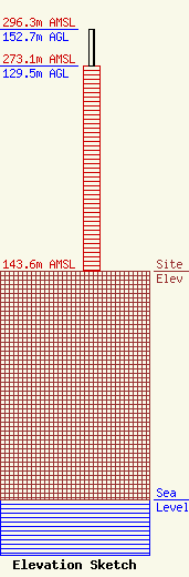
| Elevation Info |
Site Elevation: 143.6 meters (471 ft) |
| Height of Structure: 129.5 meters (425 feet) |
| Overall Height Above Ground: 152.7 meters (501 feet) |
| Overall Height Above Mean Sea Level: 296.3 meters (972 feet) |
| Owner Info | Subcarrier Communications, Inc.
139 White Oak Lane
Old Bridge, NJ 08857
(732) 607-2828
kerri@subcarrier.com |
| Contact Info | Subcarrier Communications, Inc.
139 White Oak Lane
Old Bridge, NJ 08857
John Paleski
(732) 607-2828
kerri@subcarrier.com |
