|
|
Antenna Structure Registration 1060096 |
 |
Registration Info | Registration Number: 1060096 |
| File Number: A0551618 |
| FAA Study: 2007-AEA-1530-OE |
| FAA Issue Date: 05/09/2007 |
| Status: Constructed |
| Date Constructed: 01/01/1985 |
| FAA EMI: N |
| NEPA: N |
Structure Info
| Structure Type: B |
| Structure Coordinates: 40-4-24.0 N 75-11-27.0 W (NAD 83) |
| Structure Coordinates: 40-04-23.6 N 75-11-28.4 W (Converted to NAD 27) |
| Structure Address: 7600 Stenton Avenue |
| Structure City: Philadelphia, PA |
| Structure County: Philadelphia County |
| Painting & Lighting Info |
FAA Circular #: 70/7460-1K |
FAA Chapters: 4, 8, 12 |
Remarks: PRIOR STUDY 2003-AEA-1173-OE |
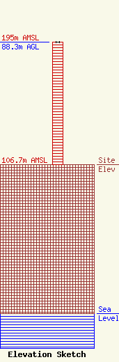
| Elevation Info |
Site Elevation: 106.7 meters (350 ft) |
| Height of Structure: 88.3 meters (290 feet) |
| Overall Height Above Ground: 88.3 meters (290 feet) |
| Overall Height Above Mean Sea Level: 195 meters (640 feet) |
| Owner Info | MORGAN TOWER, INC.
700 ROUTE 130 NORTH, SUITE 204
CINNAMINSON, NJ 08077
Leonard Stevens
(856) 786-7200
|
| Contact Info | Tower Economics
700 Route 130 North, Suite 204
Cinnaminson, NJ 08077
George Johnson
(856) 786-7200
Precom1047@aol.com |
