|
|
Antenna Structure Registration 1060435 |
 |
Registration Info | Registration Number: 1060435 |
| File Number: A0695806 |
| FAA Study: 2010-ACE-1979-OE |
| FAA Issue Date: 08/25/2010 |
| Status: Constructed |
| Date Constructed: 09/10/2010 |
| FAA EMI: N |
| NEPA: N |
Structure Info
| Structure Type: TOWER |
| Structure Coordinates: 36-44-53.5 N 93-16-38.0 W (NAD 83) |
| Structure Coordinates: 36-44-53.3 N 93-16-37.3 W (Converted to NAD 27) |
| Structure Address: 0.5 Km Ne Of Us Rte. 160 And Sr 248 |
| Structure City: Irma, MO |
| Structure County: Taney County |
| Painting & Lighting Info |
FAA Circular #: 70/7460-1K |
FAA Chapters: 4, 6, 12 |
Remarks: PRIOR STUDY 1998-ACE-1506-OE |
| Elevation Info |
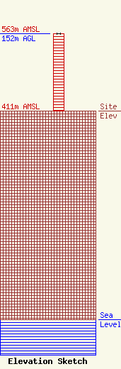
Site Elevation: 411 meters (1348 ft) |
| Height of Structure: 152 meters (499 feet) |
| Overall Height Above Ground: 152 meters (499 feet) |
| Overall Height Above Mean Sea Level: 563 meters (1847 feet) |
| Owner Info | Branson Visitors TV, LLC
3500
Springfield, MO 65808-3500
(417) 268-3010
mscott@ky3.com |
| Contact Info | Wilmer Cutler Pickering Hale and Dorr LLP
1875 Pennsylvania Avenue, NW
Washington, DC 20006
Jack Goodman
(202) 663-6287
jack.goodman@wilmerhale.com |
