|
|
Antenna Structure Registration 1061421 |
 |
Registration Info | Registration Number: 1061421 |
| File Number: A0983917 |
| FAA Study: 72-GL-0482 |
| FAA Issue Date: 03/28/1988 |
| Status: Constructed |
| Date Constructed: 06/19/1974 |
| NEPA: N |
Structure Info
|
| Structure Coordinates: 44-45-37.0 N 85-40-58.0 W (NAD 83) |
| Structure Coordinates: 44-45-37.0 N 85-40-57.7 W (Converted to NAD 27) |
| Structure Address: 5256 Cedar Run Rd |
| Structure City: Traverse City, MI |
| Structure County: Grand Traverse County |
| Painting & Lighting Info |
FCC Paragraph(s): 1, 3, 4, 13, 21 |
Remarks: RED LIGHTS/PAINT |
| Elevation Info |
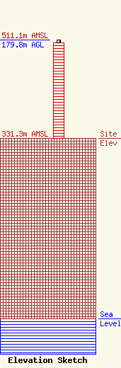
Site Elevation: 331.3 meters (1087 ft) |
| Height of Structure: 175.2 meters (575 feet) |
| Overall Height Above Ground: 179.8 meters (590 feet) |
| Overall Height Above Mean Sea Level: 511.1 meters (1677 feet) |
| Owner Info | BARBARA A MARTIN TRUST TRAVERSE BAY TOWER LEASING, LLC
5164 CEDAR RUN RD
791
TRAVERSE CITY, MI 49685-0791
(231) 620-6048
NTC@TORCHLAKE.COM |
| Contact Info | TRAVERSE BAY TOWER LEASING, LLC
5164 CEDAR RUN RD
791
TRAVERSE CITY, MI 49685
JEANNE GORDON
(231) 620-6048
NTC@TORCHLAKE.COM |
