|
|
Antenna Structure Registration 1061575 |
 |
Registration Info | Registration Number: 1061575 |
| File Number: A0072063 |
| FAA Study: 73-WE-691-OE |
| FAA Issue Date: 11/12/1973 |
| Status: Constructed |
| Date Constructed: 11/15/1973 |
| NEPA: N |
Structure Info
| Structure Type: POLE |
| Structure Coordinates: 34-13-14.0 N 118-13-50.0 W (NAD 83) |
| Structure Coordinates: 34-13-14.0 N 118-13-46.7 W (Converted to NAD 27) |
| Structure Address: 4554 Briggs Ave |
| Structure City: La Crescenta, CA |
| Structure County: Los Angeles County |
| Painting & Lighting Info |
FAA Chapters: NONE |
| Elevation Info |
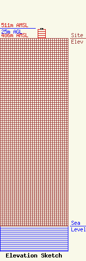
Site Elevation: 486 meters (1594 ft) |
| Height of Structure: 23 meters (75 feet) |
| Overall Height Above Ground: 25 meters (82 feet) |
| Overall Height Above Mean Sea Level: 511 meters (1677 feet) |
| Owner Info | LOS ANGELES, COUNTY OF
1110 N EASTERN AVE
LOS ANGELES, CA 90063-3297
(323) 267-3004
GPOON@CO.LA.CA.US |
