|
|
Antenna Structure Registration 1061588 |
 |
Registration Info | Registration Number: 1061588 |
| File Number: A0072076 |
| FAA Study: 77-WE-189-OE |
| FAA Issue Date: 04/29/1977 |
| Status: Constructed |
| Date Constructed: 01/01/1977 |
| NEPA: N |
Structure Info
| Structure Type: TOWER |
| Structure Coordinates: 34-14-48.0 N 118-6-17.0 W (NAD 83) |
| Structure Coordinates: 34-14-48.0 N 118-06-13.7 W (Converted to NAD 27) |
| Structure Address: Mount Disappointment |
| Structure City: Los Angeles, CA |
| Structure County: Los Angeles County |
| Painting & Lighting Info |
FAA Chapters: NONE |
| Elevation Info |
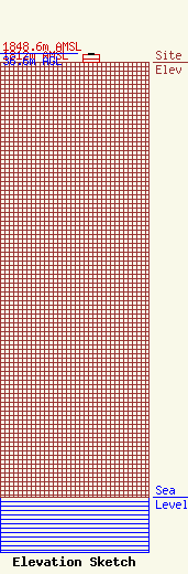
Site Elevation: 1812 meters (5945 ft) |
| Height of Structure: 30 meters (98 feet) |
| Overall Height Above Ground: 36.6 meters (120 feet) |
| Overall Height Above Mean Sea Level: 1848.6 meters (6065 feet) |
| Owner Info | LOS ANGELES, COUNTY OF
1110 N EASTERN AVE
LOS ANGELES, CA 90063-3297
(323) 267-3004
GPOON@CO.LA.CA.US |
