|
|
Antenna Structure Registration 1061601 |
 |
Registration Info | Registration Number: 1061601 |
| File Number: A0072089 |
| FAA Study: 73-WE-784-OE |
| FAA Issue Date: 12/26/1973 |
| Status: Constructed |
| Date Constructed: 03/15/1974 |
| NEPA: N |
Structure Info
| Structure Type: TOWER |
| Structure Coordinates: 34-6-11.0 N 118-4-36.0 W (NAD 83) |
| Structure Coordinates: 34-06-11.0 N 118-04-32.8 W (Converted to NAD 27) |
| Structure Address: 8838 E Las Tunas Dr |
| Structure City: Temple City, CA |
| Structure County: Los Angeles County |
| Painting & Lighting Info |
FAA Chapters: NONE |
| Elevation Info |
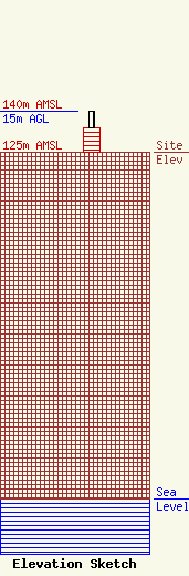
Site Elevation: 125 meters (410 ft) |
| Height of Structure: 9 meters (30 feet) |
| Overall Height Above Ground: 15 meters (49 feet) |
| Overall Height Above Mean Sea Level: 140 meters (459 feet) |
| Owner Info | LOS ANGELES, COUNTY OF
1110 N EASTERN AVE
LOS ANGELES, CA 90063-3297
(323) 267-3004
GPOON@CO.LA.CA.US |
