|
|
Antenna Structure Registration 1061628 |
 |
Registration Info | Registration Number: 1061628 |
| File Number: A0072117 |
| FAA Study: 87-ASW-1331-OE |
| FAA Issue Date: 03/11/1988 |
| Status: Terminated |
| Date Constructed: 02/25/1999 |
| NEPA: N |
Structure Info
| Structure Type: TOWER |
| Structure Coordinates: 34-44-38.0 N 92-16-33.0 W (NAD 83) |
| Structure Coordinates: 34-44-37.7 N 92-16-32.5 W (Converted to NAD 27) |
| Structure Address: 425 West Capitol Avenue |
| Structure City: Little Rock, AR |
| Structure County: Pulaski County |
| Painting & Lighting Info |
FAA Circular #: 70/7460-1G |
FAA Chapters: 4, 5, 9 |
| Elevation Info |
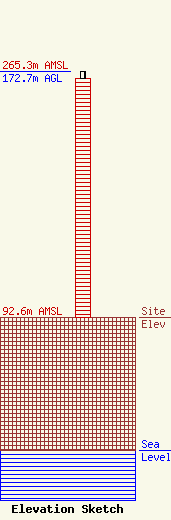
Site Elevation: 92.6 meters (304 ft) |
| Height of Structure: 167.8 meters (551 feet) |
| Overall Height Above Ground: 172.7 meters (567 feet) |
| Overall Height Above Mean Sea Level: 265.3 meters (870 feet) |
| Owner Info | MOTOROLA NORTH AMERICAN ANTENNA SITES
5096 PANOLA INDUSTRIAL BLVD.
DECATUR, GA 30035
(678) 482-9995
|
