|
|
Antenna Structure Registration 1062362 |
 |
Registration Info | Registration Number: 1062362 |
| File Number: A0072891 |
| FAA Study: 98-ASW-4477-OE |
| FAA Issue Date: 11/13/1998 |
| Status: Granted |
| NEPA: N |
Structure Info
| Structure Type: TOWER |
| Structure Coordinates: 34-43-40.0 N 92-16-23.0 W (NAD 83) |
| Structure Coordinates: 34-43-39.7 N 92-16-22.5 W (Converted to NAD 27) |
| Structure Address: 2101 S Main St |
| Structure City: Little Rock, AR |
| Structure County: Pulaski County |
| Painting & Lighting Info |
FAA Circular #: |
FAA Chapters: NONE |
Remarks: Removed expiration date from determination. Scenario 1./jjs/case#635066 |
| Elevation Info |
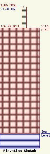
Site Elevation: 106.7 meters (350 ft) |
| Height of Structure: 21.3 meters (70 feet) |
| Overall Height Above Ground: 21.3 meters (70 feet) |
| Overall Height Above Mean Sea Level: 128 meters (420 feet) |
| Owner Info | ARKANSAS BROADCASTING FOUNDATION DBA = KABF COMMUNITY RADIO
2101 S MAIN ST STE 200
LITTLE ROCK, AR 72206
(501) 372-6119
KABF@IGC.APC.ORG |
