|
|
Antenna Structure Registration 1062582 |
 |
Registration Info | Registration Number: 1062582 |
| File Number: A0198247 |
| FAA Study: 98-AGL-2122-OE |
| FAA Issue Date: 01/23/2000 |
| Status: Constructed |
| Date Constructed: 06/26/2001 |
| FAA EMI: N |
| NEPA: N |
Structure Info
| Structure Type: TOWER |
| Structure Coordinates: 45-14-20.0 N 93-41-15.0 W (NAD 83) |
| Structure Coordinates: 45-14-20.1 N 93-41-14.1 W (Converted to NAD 27) |
| Structure Address: 1.1 Kilometers South Of I-94/u.s. 52 Interchange |
| Structure City: Albertville, MN |
| Structure County: Wright County |
| Painting & Lighting Info |
FAA Circular #: 70/7460-1J |
FAA Chapters: 3, 4, 5, 13 |
Remarks: Removed expiration date from determination. Scenario 1./jjs/case#635066 |
Remarks: EXTENSION GRANTED 01/23/00 |
| Elevation Info |
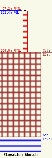
Site Elevation: 304.8 meters (1000 ft) |
| Height of Structure: 151.5 meters (497 feet) |
| Overall Height Above Ground: 152.4 meters (500 feet) |
| Overall Height Above Mean Sea Level: 457.2 meters (1500 feet) |
| Owner Info | MILESTONE RADIO, LLC
106
PRINCETON, MN 55371
(612) 389-1300
|
