|
|
Antenna Structure Registration 1063096 |
 |
Registration Info | Registration Number: 1063096 |
| File Number: A1297445 |
| FAA Study: 98-AGL-4868-OE |
| FAA Issue Date: 03/01/1999 |
| Status: Constructed |
| Date Constructed: 01/11/2000 |
| FAA EMI: N |
| NEPA: N |
Structure Info
| Structure Type: TOWER |
| Structure Coordinates: 45-3-22.0 N 89-27-54.0 W (NAD 83) |
| Structure Coordinates: 45-03-22.1 N 89-27-53.6 W (Converted to NAD 27) |
| Structure Address: Near Intersection Of Landing And Sunrise Rds |
| Structure City: Glandon, WI |
| Structure County: Marathon County |
| Painting & Lighting Info |
FAA Circular #: 70/7460-1J |
FAA Chapters: 3, 4, 9, 13 |
Remarks: Removed expiration and final dates from determination. Scenario 2./jjs/case#635066 |
| Elevation Info |
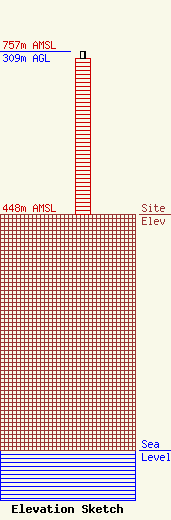
Site Elevation: 448 meters (1470 ft) |
| Height of Structure: 296 meters (971 feet) |
| Overall Height Above Ground: 309 meters (1014 feet) |
| Overall Height Above Mean Sea Level: 757 meters (2484 feet) |
| Owner Info | Gray Local Media, Inc.
4370 Peachtree Road, NE
Atlanta, GA 30319
(404) 266-8333
legalnotices@graymedia.com |
| Contact Info | Gray Local Media, Inc.
4370 Peachtree Road NE
Atlanta, GA 30319
Engineering Department
(404) 266-8333
legalnotices@graymedia.com |
