|
|
Antenna Structure Registration 1064570 |
 |
Registration Info | Registration Number: 1064570 |
| File Number: A0075221 |
| FAA Study: 74-NE-189-OE |
| FAA Issue Date: 11/20/1974 |
| Status: Constructed |
| Date Constructed: 03/05/1975 |
| NEPA: N |
Structure Info
| Structure Type: TOWER |
| Structure Coordinates: 45-10-2.0 N 67-16-36.0 W (NAD 83) |
| Structure Coordinates: 45-10-01.7 N 67-16-38.0 W (Converted to NAD 27) |
| Structure Address: 0.3 Mi S Of South St On Road To City Dump |
| Structure City: Calais, ME |
| Structure County: Washington County |
| Painting & Lighting Info |
FCC Paragraph(s): 1, 3, 11, 21 |
Remarks: RED LIGHTS/PAINT |
| Elevation Info |
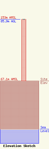
Site Elevation: 67.1 meters (220 ft) |
| Height of Structure: 85.9 meters (282 feet) |
| Overall Height Above Ground: 85.9 meters (282 feet) |
| Overall Height Above Mean Sea Level: 153 meters (502 feet) |
| Owner Info | WQDY, INC.
281 MAIN STREET
CALAIS, ME 04619
(207) 454-7545
|
