|
|
Antenna Structure Registration 1065310 |
 |
Registration Info | Registration Number: 1065310 |
| File Number: A1327488 |
| FAA Study: 87-AEA-0490-OE |
| FAA Issue Date: 06/22/1987 |
| Status: Constructed |
| Date Constructed: 05/01/1968 |
| NEPA: N |
Structure Info
|
| Structure Coordinates: 42-3-22.0 N 75-56-38.0 W (NAD 83) |
| Structure Coordinates: 42-03-21.7 N 75-56-39.3 W (Converted to NAD 27) |
| Structure Address: 3000 Ingraham Hill Rd |
| Structure City: Binghamton, NY |
| Structure County: Broome County |
| Painting & Lighting Info |
FCC Paragraph(s): 1, 3, 6, 15, 21 |
Remarks: RED LIGHTS/PAINT |
| Elevation Info |
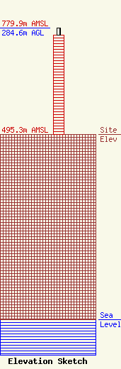
Site Elevation: 495.3 meters (1625 ft) |
| Height of Structure: 265.4 meters (871 feet) |
| Overall Height Above Ground: 284.6 meters (934 feet) |
| Overall Height Above Mean Sea Level: 779.9 meters (2559 feet) |
| Owner Info | Station RE Holdings LLC
3507
Jackson, MS 39207
(601) 360-9312
wcollums@aol.com |
| Contact Info | Baker & Hostetler LLP
1050 Connecticut Ave NW
Washington, DC 20036
Daniel Kirkpatrick
(202) 861-1758
dkirkpatrick@bakerlaw.com |
