|
|
Antenna Structure Registration 1065410 |
 |
Registration Info | Registration Number: 1065410 |
| File Number: A0076067 |
| FAA Study: 99-ACE-0560-OE |
| Status: Constructed |
| Date Constructed: 10/21/1985 |
| NEPA: N |
Structure Info
| Structure Type: TOWER |
| Structure Coordinates: 37-40-40.0 N 92-41-24.0 W (NAD 83) |
| Structure Coordinates: 37-40-39.9 N 92-41-23.4 W (Converted to NAD 27) |
| Structure Address: Radio Park, New Buffalo Road, 1.6 Km. West Of |
| Structure City: Lebanon, MO |
| Structure County: Laclede County |
| Painting & Lighting Info |
FAA Circular #: |
FCC Paragraph(s): 1, 3, 4, 13, 21 |
| Elevation Info |
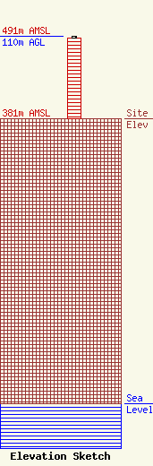
Site Elevation: 381 meters (1250 ft) |
| Height of Structure: 108.5 meters (356 feet) |
| Overall Height Above Ground: 110 meters (361 feet) |
| Overall Height Above Mean Sea Level: 491 meters (1611 feet) |
| Owner Info | LEBANON BROADCASTING AND LEASING LTD., INC.
18785 FINCH ROAD
LEBANON, MO 65536
(417) 335-2261
MHENDEE@PEARSONBROADCASTING.COM |
