|
|
Antenna Structure Registration 1065577 |
 |
Registration Info | Registration Number: 1065577 |
| File Number: A1342717 |
| FAA Study: 2016-AGL-9276-OE |
| FAA Issue Date: 10/05/2016 |
| Status: Constructed |
| Date Constructed: 10/05/2016 |
| NEPA: N |
Structure Info
| Structure Type: GTOWER |
| Structure Coordinates: 44-18-11.5 N 96-46-2.4 W (NAD 83) |
| Structure Coordinates: 44-18-11.6 N 96-46-01.2 W (Converted to NAD 27) |
| Structure Address: 227 22nd Ave S |
| Structure City: Brookings, SD |
| Structure County: Brookings County |
| Painting & Lighting Info |
FAA Circular #: 70/7460-1L |
FAA Chapters: 3, 4, 5, 12 |
Remarks: PRIOR STUDY 2016-AGL-282-OE |
| Elevation Info |
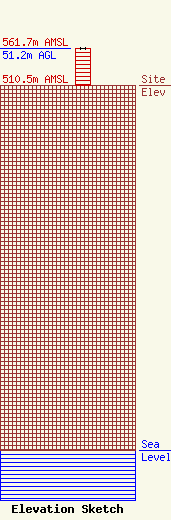
Site Elevation: 510.5 meters (1675 ft) |
| Height of Structure: 51.2 meters (168 feet) |
| Overall Height Above Ground: 51.2 meters (168 feet) |
| Overall Height Above Mean Sea Level: 561.7 meters (1843 feet) |
| Owner Info | VB-S1 Assets, LLC
22 W Atlantic Avenue
Delray Beach, FL 33444
(561) 406-4015
fcc-faa@verticalbridge.com |
| Contact Info | VB-S1 Assets, LLC
22 W Atlantic Avenue
Delray Beach, FL 33444
Richard Hickey
(561) 406-4015
fcc-faa@verticalbridge.com |
