|
|
Antenna Structure Registration 1066090 |
 |
Registration Info | Registration Number: 1066090 |
| File Number: A0076747 |
| FAA Study: 85-ASW-2202-OE |
| FAA Issue Date: 02/10/1986 |
| Status: Constructed |
| Date Constructed: 01/01/1988 |
| NEPA: N |
Structure Info
| Structure Type: TOWER |
| Structure Coordinates: 33-22-54.0 N 96-24-46.0 W (NAD 83) |
| Structure Coordinates: 33-22-53.6 N 96-24-45.1 W (Converted to NAD 27) |
| Structure Address: 3/4 Mi Sw 400 Yds N Hwy 121 |
| Structure City: Desert, TX |
| Structure County: Collin County |
| Painting & Lighting Info |
FCC Paragraph(s): 1, 3, 12, 21 |
Remarks: RED LIGHTS/PAINT |
| Elevation Info |
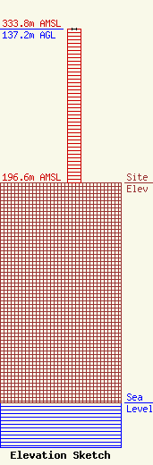
Site Elevation: 196.6 meters (645 ft) |
| Height of Structure: 137.2 meters (450 feet) |
| Overall Height Above Ground: 137.2 meters (450 feet) |
| Overall Height Above Mean Sea Level: 333.8 meters (1095 feet) |
| Owner Info | REGION 10 EDUCATION SERVICE CENTER
400 E SPRING VALLEY
RICHARDSON, TX 75083-1300
(972) 348-1700
HTTP://WWW.ESC10.EDNET10.NET |
