|
|
Antenna Structure Registration 1200273 |
 |
Registration Info | Registration Number: 1200273 |
| File Number: A1366107 |
| FAA Study: 2009-ASW-517-OE |
| FAA Issue Date: 03/10/2023 |
| Status: Constructed |
| Date Constructed: 02/09/2000 |
| FAA EMI: N |
| NEPA: N |
Structure Info
| Structure Type: TOWER |
| Structure Coordinates: 30-2-56.8 N 90-28-28.4 W (NAD 83) |
| Structure Coordinates: 30-02-56.1 N 90-28-28.1 W (Converted to NAD 27) |
| Structure Address: River Road |
| Structure City: Laplace, LA |
| Structure County: St. John the Baptist Parish |
| Painting & Lighting Info |
FAA Circular #: 70/7460-1J |
FAA Chapters: 4, 8, 13 |
Remarks: PRIOR STUDY 2007-ASW-5544-OE |
Remarks: Unterminate FAA Study and ensure it is active in our database./da/case#1140318 |
Remarks: OM&L to remain the same as prior study = A MED-DUAL SYSTEM |
Remarks: PRIOR STUDY 2007-ASW-5544-OE |
Remarks: Unterminate FAA Study and ensure it is active in our database./da/case#1140318 |
Remarks: OM&L to remain the same as prior study = A MED-DUAL SYSTEM |
| Elevation Info |
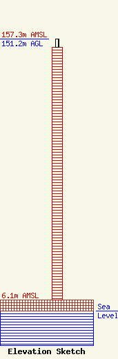
Site Elevation: 6.1 meters (20 ft) |
| Height of Structure: 146.6 meters (481 feet) |
| Overall Height Above Ground: 151.2 meters (496 feet) |
| Overall Height Above Mean Sea Level: 157.3 meters (516 feet) |
| Owner Info | Pinnacle Towers LLC
2000 Corporate Drive
Canonsburg, PA 15317
(724) 416-2400
Regulatory.Department@crowncastle.com |
| Contact Info | Crown Castle
2000 Corporate Drive
Canonsburg, PA 15317
Tom Anderson
(724) 743-6330
Tom.Anderson@crowncastle.com |
