|
|
Antenna Structure Registration 1200480 |
 |
Registration Info | Registration Number: 1200480 |
| File Number: A0222847 |
| FAA Study: 99-ANE-0269-OE |
| FAA Issue Date: 07/21/1999 |
| Status: Constructed |
| Date Constructed: 03/23/1994 |
| FAA EMI: N |
| NEPA: N |
Structure Info
| Structure Type: TOWER |
| Structure Coordinates: 43-25-5.2 N 70-48-2.3 W (NAD 83) |
| Structure Coordinates: 43-25-04.9 N 70-48-04.1 W (Converted to NAD 27) |
| Structure Address: Off Mt. Hope Road |
| Structure City: Sanford, ME |
| Structure County: York County |
| Painting & Lighting Info |
FAA Circular #: 70/7460-1H |
FAA Chapters: 3, 4, 5, 13 |
Remarks: OM&L CONTINUE PAINT/RED LIGHTS. PRIOR FAA 93-ANE-199-OE |
| Elevation Info |
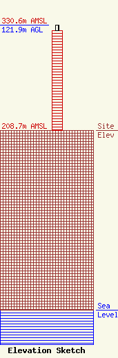
Site Elevation: 208.7 meters (685 ft) |
| Height of Structure: 115.8 meters (380 feet) |
| Overall Height Above Ground: 121.9 meters (400 feet) |
| Overall Height Above Mean Sea Level: 330.6 meters (1085 feet) |
| Owner Info | Tower Specialists, Inc.
35 Hardy Road
Falmouth, ME 04105
(207) 797-8325
|
| Contact Info | Tower Specialists, Inc.
35 Hardy Road
Falmouth, ME 04105
Paul Strout
(207) 797-8325
|
