|
|
Antenna Structure Registration 1202500 |
 |
Registration Info | Registration Number: 1202500 |
| File Number: A1354504 |
| FAA Study: 2016-ANM-71-OE |
| FAA Issue Date: 06/03/2016 |
| Status: Constructed |
| Date Constructed: 09/30/2006 |
| NEPA: N |
Structure Info
| Structure Type: MTOWER |
| Structure Coordinates: 47-0-56.2 N 122-55-3.5 W (NAD 83) |
| Structure Coordinates: 47-00-56.9 N 122-54-59.0 W (Converted to NAD 27) |
| Structure Address: 1102 Barnes Blvd. Sw |
| Structure City: Tumwater, WA |
| Structure County: Thurston County |
| Painting & Lighting Info |
FAA Chapters: NONE |
Remarks: PRIOR STUDY 2009-ANM-1207-OE |
| Elevation Info |
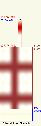
Site Elevation: 127.7 meters (419 ft) |
| Height of Structure: 56.4 meters (185 feet) |
| Overall Height Above Ground: 58.8 meters (193 feet) |
| Overall Height Above Mean Sea Level: 186.5 meters (612 feet) |
| Owner Info | CCATT LLC
2000 Corporate Drive
Canonsburg, PA 15317
(724) 416-2000
Regulatory.Department@crowncastle.com |
| Contact Info | Crown Castle
2000 Corporate Drive
Canonsburg, PA 15317
Tom Anderson
(724) 743-6330
Tom.Anderson@crowncastle.com |
