|
|
Antenna Structure Registration 1202687 |
 |
Registration Info | Registration Number: 1202687 |
| File Number: A0937025 |
| FAA Study: 2011-AEA-595-OE |
| FAA Issue Date: 04/22/2011 |
| Status: Constructed |
| Date Constructed: 09/08/2000 |
| FAA EMI: N |
| NEPA: N |
Structure Info
| Structure Type: TOWER |
| Structure Coordinates: 40-51-19.7 N 74-46-40.8 W (NAD 83) |
| Structure Coordinates: 40-51-19.3 N 74-46-42.2 W (Converted to NAD 27) |
| Structure Address: 429 Sand Shore Road |
| Structure City: Mt. Olive Township, NJ |
| Structure County: Morris County |
| Painting & Lighting Info |
FAA Circular #: 70/7460-1K |
FAA Chapters: 4, 6, 12 |
Remarks: PRIOR STUDY 1999-AEA-168-OE |
| Elevation Info |
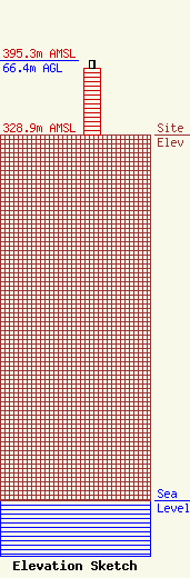
Site Elevation: 328.9 meters (1079 ft) |
| Height of Structure: 60 meters (197 feet) |
| Overall Height Above Ground: 66.4 meters (218 feet) |
| Overall Height Above Mean Sea Level: 395.3 meters (1297 feet) |
| Owner Info | Budd Lake Tower, LLC
100 Route 46 West
Box 1000
Hackettstown, NJ 07840
(908) 850-1000
info@wrnj.com |
| Contact Info | Budd Lake Tower
100 Route 46 West
Box 1000
Hackettstown, NJ 07840
Lawrence Tighe
(908) 850-1000
info@wrnj.com |
