|
|
Antenna Structure Registration 1203174 |
 |
Registration Info | Registration Number: 1203174 |
| File Number: A0280064 |
| FAA Study: 94-ASO-1650-OE |
| FAA Issue Date: 08/10/1995 |
| Status: Constructed |
| Date Constructed: 02/08/1995 |
| FAA EMI: N |
| NEPA: N |
Structure Info
| Structure Type: TOWER |
| Structure Coordinates: 33-47-18.3 N 84-24-54.7 W (NAD 83) |
| Structure Coordinates: 33-47-17.9 N 84-24-55.0 W (Converted to NAD 27) |
| Structure Address: 1350 Howell Mill Road, N.w. (huff Roadsite) |
| Structure City: Atlanta, GA |
| Structure County: Fulton County |
| Painting & Lighting Info |
FAA Circular #: 70/7460-1H |
FAA Chapters: 4, 6, 13 |
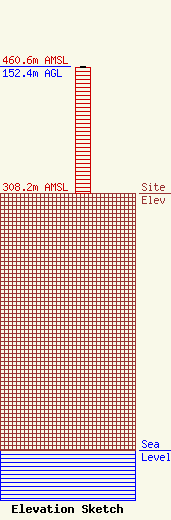
| Elevation Info |
Site Elevation: 308.2 meters (1011 ft) |
| Height of Structure: 150.3 meters (493 feet) |
| Overall Height Above Ground: 152.4 meters (500 feet) |
| Overall Height Above Mean Sea Level: 460.6 meters (1511 feet) |
| Owner Info | CITY OF ATLANTA
675 PONCE DELEON AVE
ATLANTA, GA 30308
(404) 853-7823
|
| Contact Info | ATLANTA POLICE ELECTRONIC MAINTENANCE UNIT
675 PONCE DE LEON AVENUE
ATLANTA, GA 30308
CEDRIC CROCHRAN
(404) 853-7829
|
