|
|
Antenna Structure Registration 1203253 |
 |
Registration Info | Registration Number: 1203253 |
| File Number: A0530974 |
| FAA Study: 99-AGL-2519-OE |
| FAA Issue Date: 06/28/1999 |
| Status: Constructed |
| Date Constructed: 09/28/1999 |
| FAA EMI: N |
| NEPA: N |
Structure Info
| Structure Type: TOWER |
| Structure Coordinates: 38-39-47.2 N 88-31-5.2 W (NAD 83) |
| Structure Coordinates: 38-39-47.0 N 88-31-05.0 W (Converted to NAD 27) |
| Structure Address: Old Rt. 50 West From Sunnyside Subdivision |
| Structure City: Flora, IL |
| Structure County: Clay County |
| Painting & Lighting Info |
FCC Paragraph(s): 1, 3, 11, 21 |
Remarks: OM&L PAINTED/RED LIGHTS |
| Elevation Info |
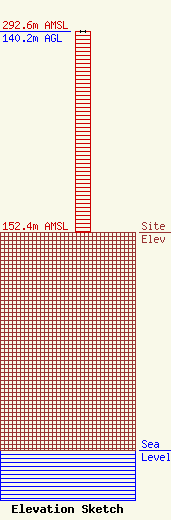
Site Elevation: 152.4 meters (500 ft) |
| Height of Structure: 140.2 meters (460 feet) |
| Overall Height Above Ground: 140.2 meters (460 feet) |
| Overall Height Above Mean Sea Level: 292.6 meters (960 feet) |
| Owner Info | Wabash Independent Networks, Inc.
P.O. 299
Louisville, IL 62858
(618) 665-3311
wabashtel@wabash.net |
| Info |
