|
|
Antenna Structure Registration 1203455 |
 |
Registration Info | Registration Number: 1203455 |
| File Number: A0144882 |
| FAA Study: 99-ASW-1853-OE |
| FAA Issue Date: 06/23/1999 |
| Status: Constructed |
| Date Constructed: 06/23/2000 |
| FAA EMI: N |
| NEPA: N |
Structure Info
| Structure Type: TOWER |
| Structure Coordinates: 36-11-28.4 N 94-33-59.3 W (NAD 83) |
| Structure Coordinates: 36-11-28.1 N 94-33-58.5 W (Converted to NAD 27) |
| Structure Address: University Ave. And Disposal Rd. |
| Structure City: Siloam Springs, AR |
| Structure County: Benton County |
| Painting & Lighting Info |
FAA Circular #: 70/7460-1J |
FAA Chapters: 4, 6, 13 |
Remarks: Removed expiration and final dates from determination. Scenario 2./jjs/case#635066 |
| Elevation Info |
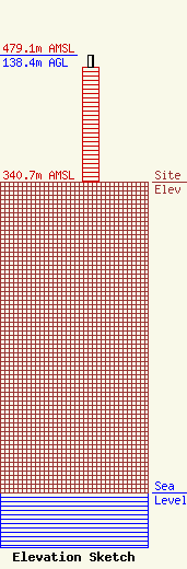
Site Elevation: 340.7 meters (1118 ft) |
| Height of Structure: 125.3 meters (411 feet) |
| Overall Height Above Ground: 138.4 meters (454 feet) |
| Overall Height Above Mean Sea Level: 479.1 meters (1572 feet) |
| Owner Info | John Brown University
2000 W University
Siloam Springs, AR 72761
(501) 524-9500
|
| Contact Info | KLRC Radio
206 N Anderson
Siloam Springs, AR 72761
Norman McChristian
(501) 524-9500
|
