|
|
Antenna Structure Registration 1204036 |
 |
Registration Info | Registration Number: 1204036 |
| File Number: A1216761 |
| FAA Study: 00-AAL-0193-OE |
| FAA Issue Date: 08/07/2000 |
| Status: Constructed |
| Date Constructed: 08/14/2000 |
| FAA EMI: N |
| NEPA: N |
Structure Info
| Structure Type: TOWER |
| Structure Coordinates: 61-20-8.8 N 149-30-56.2 W (NAD 83) |
| Structure Coordinates: 61-20-10.8 N 149-30-48.2 W (Converted to NAD 27) |
| Structure Address: Lot 1, Block 1, Eagle's Nest Subdivision |
| Structure City: Eagle River, AK |
| Structure County: Anchorage Municipality |
| Painting & Lighting Info |
FAA Circular #: 70/7460-1J |
FAA Chapters: 4, 5 |
Remarks: PRIOR FAA 97-AAL-0115-OE |
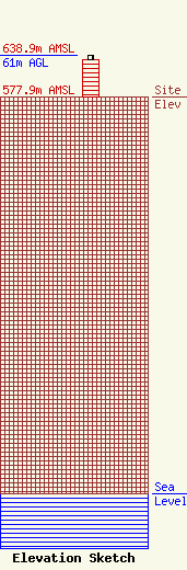
| Elevation Info |
Site Elevation: 577.9 meters (1896 ft) |
| Height of Structure: 54.8 meters (180 feet) |
| Overall Height Above Ground: 61 meters (200 feet) |
| Overall Height Above Mean Sea Level: 638.9 meters (2096 feet) |
| Owner Info | ACS Wireless, Inc.
600 Telephone Ave.
Anchorage, AK 99515
(907) 297-3130
regaffair@acsalaska.com |
| Contact Info | Wilkinson Barker Knauer, LLP
1800 M Street, NW
Washington, DC 20036
(202) 783-4141
acs@wbklaw.com |
