|
|
Antenna Structure Registration 1204113 |
 |
Registration Info | Registration Number: 1204113 |
| File Number: A1215965 |
| FAA Study: 2021-AGL-27561-OE |
| FAA Issue Date: 12/06/2021 |
| Status: Constructed |
| Date Constructed: 02/10/2022 |
| NEPA: N |
Structure Info
| Structure Type: GTOWER |
| Structure Coordinates: 42-19-41.1 N 89-43-30.4 W (NAD 83) |
| Structure Coordinates: 42-19-41.0 N 89-43-30.0 W (Converted to NAD 27) |
| Structure Address: 5817 Us Route 20 West |
| Structure City: Freeport, IL |
| Structure County: Stephenson County |
| Painting & Lighting Info |
FAA Circular #: 70/7460-1M |
FAA Chapters: 4, 8, 15 |
Remarks: PRIOR STUDY 2014-AGL-11035-OE |
| Elevation Info |
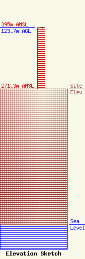
Site Elevation: 271.3 meters (890 ft) |
| Height of Structure: 123.7 meters (406 feet) |
| Overall Height Above Ground: 123.7 meters (406 feet) |
| Overall Height Above Mean Sea Level: 395 meters (1296 feet) |
| Info |
| Info |
