|
|
Antenna Structure Registration 1206320 |
 |
Registration Info | Registration Number: 1206320 |
| File Number: A0572541 |
| FAA Study: 99-AWP-2068-OE |
| Status: Terminated |
| Date Constructed: 12/08/1999 |
| FAA EMI: N |
| NEPA: N |
Structure Info
| Structure Type: POLE |
| Structure Coordinates: 34-9-10.0 N 118-9-0.0 W (NAD 83) |
| Structure Coordinates: 34-09-10.0 N 118-08-56.7 W (Converted to NAD 27) |
| Structure Address: 444 Fair Oaks Avenue |
| Structure City: Pasadena, CA |
| Structure County: Los Angeles County |
| Painting & Lighting Info |
FAA Chapters: NONE |
| Elevation Info |
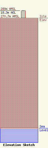
Site Elevation: 270.7 meters (888 ft) |
| Height of Structure: 18.3 meters (60 feet) |
| Overall Height Above Ground: 18.3 meters (60 feet) |
| Overall Height Above Mean Sea Level: 289 meters (948 feet) |
| Owner Info | NEW CINGULAR WIRELESS PCS, LLC
5601 LEGACY DRIVE, MS: A-3
PLANO, TX 75024
(469) 229-7422
KA8805@ATT.COM |
| Contact Info | AT&T MOBILITY LLC
5601 LEGACY DRIVE, MS: A-3
PLANO, TX 75024
KELLYE ABERNATHY
(469) 229-7422
KA8805@ATT.COM |
