|
|
Antenna Structure Registration 1206513 |
 |
Registration Info | Registration Number: 1206513 |
| File Number: A0257255 |
| FAA Study: 86-AEA-1819-OE |
| Status: Constructed |
| Date Constructed: 08/01/1987 |
| FAA EMI: N |
| NEPA: N |
Structure Info
| Structure Type: TOWER |
| Structure Coordinates: 44-42-20.1 N 73-28-56.4 W (NAD 83) |
| Structure Coordinates: 44-42-19.9 N 73-28-57.9 W (Converted to NAD 27) |
| Structure Address: 1 Sesame Street |
| Structure City: Plattsburgh, NY |
| Structure County: Clinton County |
| Painting & Lighting Info |
FAA Chapters: NONE |
| Elevation Info |
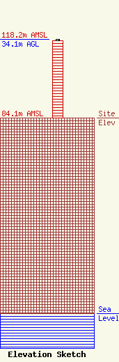
Site Elevation: 84.1 meters (276 ft) |
| Height of Structure: 33.5 meters (110 feet) |
| Overall Height Above Ground: 34.1 meters (112 feet) |
| Overall Height Above Mean Sea Level: 118.2 meters (388 feet) |
| Owner Info | Mountain Lake Public Telecommunications Council
One Sesame St
Plattsburgh, NY 12901
(518) 563-9770
|
| Contact Info | Mountain Lake Public Telecommunications Council
One Sesame St
Plattsburgh, NY 12901
Howard Lowe
(518) 563-9770
|
