|
|
Antenna Structure Registration 1207475 |
 |
Registration Info | Registration Number: 1207475 |
| File Number: A1332614 |
| FAA Study: 2025-ASO-8423-OE |
| FAA Issue Date: 06/24/2025 |
| Status: Constructed |
| Date Constructed: 12/07/1999 |
| NEPA: N |
Structure Info
| Structure Type: GTOWER |
| Structure Coordinates: 35-17-28.0 N 81-34-2.1 W (NAD 83) |
| Structure Coordinates: 35-17-27.5 N 81-34-02.8 W (Converted to NAD 27) |
| Structure Address: 1511 Dixon Boulevard (209213) |
| Structure City: Shelby, NC |
| Structure County: Cleveland County |
| Painting & Lighting Info |
FAA Circular #: 70/7460-1L |
FAA Chapters: 4, 8, 12 |
Remarks: OM&L to remain the same as prior studies = A MED-DUAL SYSTEM |
Remarks: PRIOR STUDY 1999-ASO-5344-OE / 2019-ASO-35091-OE |
Remarks: OM&L to remain the same as prior studies = A MED-DUAL SYSTEM |
| Elevation Info |
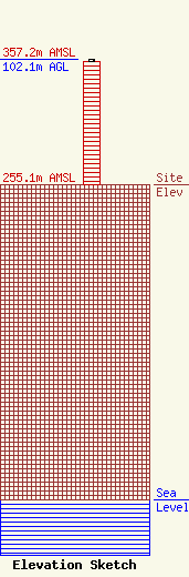
Site Elevation: 255.1 meters (837 ft) |
| Height of Structure: 100 meters (328 feet) |
| Overall Height Above Ground: 102.1 meters (335 feet) |
| Overall Height Above Mean Sea Level: 357.2 meters (1172 feet) |
| Owner Info | American Towers LLC
10 Presidential Way
Woburn, MA 01801
(781) 926-4500
faa-fcc@americantower.com |
| Contact Info | American Towers LLC
10 Presidential Way
Woburn, MA 01801
(781) 926-4500
faa-fcc@americantower.com |
