|
|
Antenna Structure Registration 1209121 |
 |
Registration Info | Registration Number: 1209121 |
| File Number: A0282860 |
| FAA Study: 2002-AEA-2611-OE |
| FAA Issue Date: 08/16/2002 |
| Status: Constructed |
| Date Constructed: 09/23/2002 |
| FAA EMI: N |
| NEPA: N |
Structure Info
| Structure Type: 6TA6 |
| Structure Coordinates: 39-22-33.0 N 76-51-24.0 W (NAD 83) |
| Structure Coordinates: 39-22-32.6 N 76-51-25.1 W (Converted to NAD 27) |
| Structure Address: 5280 Hernwood Road |
| Structure City: Randallstown, MD |
| Structure County: Baltimore County |
| Painting & Lighting Info |
FAA Circular #: 70/7460-1K |
FAA Chapters: 3, 4, 5, 12 |
Remarks: PRIOR STUDY 1999-AEA-3986-OE |
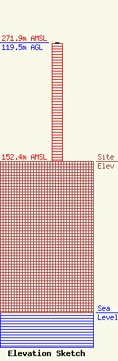
| Elevation Info |
Site Elevation: 152.4 meters (500 ft) |
| Height of Structure: 118.6 meters (389 feet) |
| Overall Height Above Ground: 119.5 meters (392 feet) |
| Overall Height Above Mean Sea Level: 271.9 meters (892 feet) |
| Owner Info | WCBM Maryland, Inc.
1205 York Road #39C
Lutherville, MD 21093
(410) 825-8400
|
| Contact Info | Carl E. Smith Consulting Engineers
2324 North Cleveland-Massillon Road
807
Bath, OH 44210-0807
Roy Stype
(330) 659-4440
|
