|
|
Antenna Structure Registration 1209391 |
 |
Registration Info | Registration Number: 1209391 |
| File Number: A1113859 |
| FAA Study: 99-ASO-6501-OE |
| FAA Issue Date: 01/25/2000 |
| Status: Constructed |
| Date Constructed: 06/15/1985 |
| FAA EMI: N |
| NEPA: N |
Structure Info
| Structure Type: TOWER |
| Structure Coordinates: 32-25-15.0 N 80-41-18.0 W (NAD 83) |
| Structure Coordinates: 32-25-14.3 N 80-41-18.6 W (Converted to NAD 27) |
| Structure Address: 105 South Riabaut Road |
| Structure City: Beaufort, SC |
| Structure County: Beaufort County |
| Painting & Lighting Info |
FAA Chapters: NONE |
| Elevation Info |
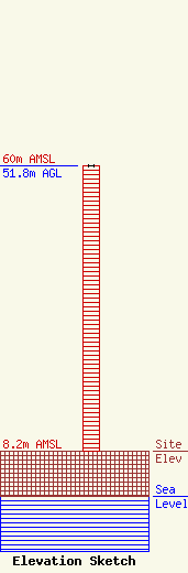
Site Elevation: 8.2 meters (27 ft) |
| Height of Structure: 51.8 meters (170 feet) |
| Overall Height Above Ground: 51.8 meters (170 feet) |
| Overall Height Above Mean Sea Level: 60 meters (197 feet) |
| Owner Info | South Carolina Educational TV Commission
1041 George Rogers Blvd
Columbia, SC 29201-4761
(803) 737-3500
mjahnke@scetv.org |
| Contact Info | SCETV
1041 George Rogers Blvd
Columbia, SC 29201-4761
Mark Jahnke
(803) 737-3500
mjahnke@scetv.org |
