|
|
Antenna Structure Registration 1209471 |
 |
Registration Info | Registration Number: 1209471 |
| File Number: A1358770 |
| FAA Study: 2025-ASW-9076-OE |
| FAA Issue Date: 09/30/2025 |
| Status: Constructed |
| Date Constructed: 11/12/2017 |
| NEPA: N |
Structure Info
| Structure Type: GTOWER |
| Structure Coordinates: 32-22-37.2 N 94-34-18.4 W (NAD 83) |
| Structure Coordinates: 32-22-36.6 N 94-34-17.7 W (Converted to NAD 27) |
| Structure Address: 5.5 Miles Northwest Of Tatum, Tx On Rusk County Road 2211 |
| Structure City: Tatum, TX |
| Structure County: Rusk County |
| Painting & Lighting Info |
FAA Circular #: 70/7460-1M |
FAA Chapters: 4, 8, 15 |
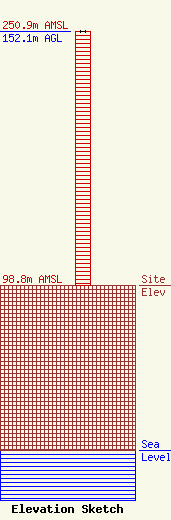
| Elevation Info |
Site Elevation: 98.8 meters (324 ft) |
| Height of Structure: 152.1 meters (499 feet) |
| Overall Height Above Ground: 152.1 meters (499 feet) |
| Overall Height Above Mean Sea Level: 250.9 meters (823 feet) |
| Owner Info | Chalk Hill Communications, LLC
13618 County Road 2127 North
Henderson, TX 75652
(903) 643-7711
chuck@qx-fm.com |
| Contact Info | KZQX & KDOK Radio
P.O. Box 1008
1008
KIlgore, TX 75663
Chuck Conrad
(903) 643-7711
chuck@qx-fm.com |
