|
|
Antenna Structure Registration 1209875 |
 |
Registration Info | Registration Number: 1209875 |
| File Number: A0402245 |
| FAA Study: 2003-ASO-4809-OE |
| FAA Issue Date: 09/30/2003 |
| Status: Constructed |
| Date Constructed: 10/21/2003 |
| FAA EMI: Y |
| NEPA: N |
Structure Info
| Structure Type: TOWER |
| Structure Coordinates: 32-17-43.2 N 90-14-46.3 W (NAD 83) |
| Structure Coordinates: 32-17-42.7 N 90-14-46.0 W (Converted to NAD 27) |
| Structure Address: 3551 J. R. Lynch Street Extension |
| Structure City: Jackson, MS |
| Structure County: Hinds County |
| Painting & Lighting Info |
FAA Circular #: 70/7460-1H |
FAA Chapters: 4, 5, 7, 9, 13 |
Remarks: PRIOR STUDY 1993-ASO-2093-OE |
Remarks: Continue As Is OM&L = A MED-DUAL SYSTEM |
Remarks: PRIOR STUDY 1993-ASO-2093-OE |
Remarks: Continue As Is OM&L = A MED-DUAL SYSTEM |
| Elevation Info |
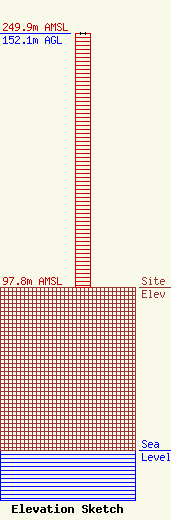
Site Elevation: 97.8 meters (321 ft) |
| Height of Structure: 152.1 meters (499 feet) |
| Overall Height Above Ground: 152.1 meters (499 feet) |
| Overall Height Above Mean Sea Level: 249.9 meters (820 feet) |
| Owner Info | CITY OF JACKSON MISSISSIPPI
2320 Riverside Drive
Jackson, MS 39202
(601) 960-1696
SHOLSTON@CITY.JACKSON.MS.US |
| Contact Info | CITY OF JACKSON MISSISSIPPI
2320 RIVERSIDE DRIVE
JACKSON, MS 39202
(601) 960-1696
sholston@CITY.JACKSON.MS.US |
