|
|
Antenna Structure Registration 1210033 |
 |
Registration Info | Registration Number: 1210033 |
| File Number: A1054147 |
| FAA Study: 99-AWP-1693-OE |
| FAA Issue Date: 02/04/2000 |
| Status: Constructed |
| Date Constructed: 03/12/2001 |
| FAA EMI: N |
| NEPA: N |
Structure Info
| Structure Type: TOWER |
| Structure Coordinates: 33-44-46.0 N 118-20-10.0 W (NAD 83) |
| Structure Coordinates: 33-44-45.9 N 118-20-06.7 W (Converted to NAD 27) |
| Structure Address: 3960 Crest Road |
| Structure City: Rolling Hills, CA |
| Structure County: Los Angeles County |
| Painting & Lighting Info |
FAA Chapters: NONE |
Remarks: Removed expiration date from determination. Scenario 1./jjs/case#635066 |
Remarks: PRIOR FAA 99-AWP-1449-OE |
Remarks: Removed expiration date from determination. Scenario 1./jjs/case#635066 |
Remarks: PRIOR FAA 99-AWP-1449-OE |
| Elevation Info |
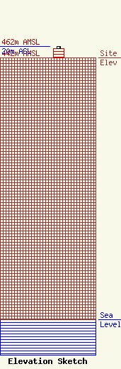
Site Elevation: 442 meters (1450 ft) |
| Height of Structure: 16 meters (52 feet) |
| Overall Height Above Ground: 20 meters (66 feet) |
| Overall Height Above Mean Sea Level: 462 meters (1516 feet) |
| Owner Info | Los Angeles, City of
200 N. Main Street Room 1258
Loa Angeles, CA 90012
(213) 978-0832
omotayo.ige@lacity.org |
| Contact Info | Los Angeles, City of
200 N. Main Street Room 1258
Los Angeles, CA 90012
Kennth Mann
(213) 978-0832
ken.mann@lacity.org |
