|
|
Antenna Structure Registration 1210439 |
 |
Registration Info | Registration Number: 1210439 |
| File Number: A1196581 |
| FAA Study: 2020-ANE-4459-OE |
| FAA Issue Date: 07/24/2020 |
| Status: Constructed |
| Date Constructed: 09/01/2000 |
| NEPA: N |
Structure Info
| Structure Type: GTOWER |
| Structure Coordinates: 43-39-31.5 N 73-6-23.6 W (NAD 83) |
| Structure Coordinates: 43-39-31.3 N 73-06-25.2 W (Converted to NAD 27) |
| Structure Address: Summit Of Grandpa Knob |
| Structure City: Castleton, VT |
| Structure County: Rutland County |
| Painting & Lighting Info |
FAA Circular #: 70/7460-1L |
FAA Chapters: 4, 8, 12 |
| Elevation Info |
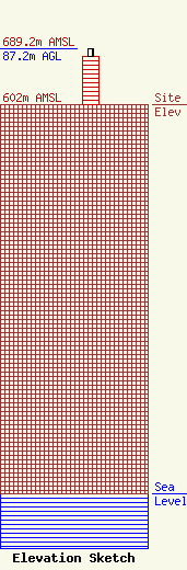
Site Elevation: 602 meters (1975 ft) |
| Height of Structure: 74.7 meters (245 feet) |
| Overall Height Above Ground: 87.2 meters (286 feet) |
| Overall Height Above Mean Sea Level: 689.2 meters (2261 feet) |
| Owner Info | Vermont Public Co.
365 Troy Avenue
Colchester, VT 05446
(802) 846-8309
sferreira@vermontpbs.org |
| Contact Info | Foster Garvey P.C.
1000 Potomac St., NW
Washington, DC 20007
Brad Deutsch
(202) 298-1793
brad.deutsch@foster.com |
