|
|
Antenna Structure Registration 1210532 |
 |
Registration Info | Registration Number: 1210532 |
| File Number: A1261708 |
| FAA Study: 2023-ASW-15895-OE |
| FAA Issue Date: 11/07/2023 |
| Status: Constructed |
| Date Constructed: 02/22/2000 |
| NEPA: N |
Structure Info
| Structure Type: LTOWER |
| Structure Coordinates: 32-46-42.5 N 96-46-30.3 W (NAD 83) |
| Structure Coordinates: 32-46-42.0 N 96-46-29.3 W (Converted to NAD 27) |
| Structure Address: 1810 Jeffries Street |
| Structure City: Dallas, TX |
| Structure County: Dallas County |
| Painting & Lighting Info |
FAA Circular #: 70/7460-1J |
FAA Chapters: 4, 8, 13 |
Remarks: OM&L to remain the same as prior study = A MED-DUAL SYSTEM |
Remarks: PRIOR STUDY 1999-ASW-2188-OE |
Remarks: OM&L to remain the same as prior study = A MED-DUAL SYSTEM |
Remarks: PRIOR STUDY 1999-ASW-2188-OE |
| Elevation Info |
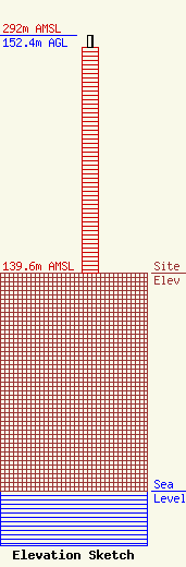
Site Elevation: 139.6 meters (458 ft) |
| Height of Structure: 144.8 meters (475 feet) |
| Overall Height Above Ground: 152.4 meters (500 feet) |
| Overall Height Above Mean Sea Level: 292 meters (958 feet) |
| Owner Info | American Towers LLC
10 Presidential Way
Woburn, MA 01801
(781) 926-4500
faa-fcc@americantower.com |
| Contact Info | American Towers LLC
10 Presidential Way
Woburn, MA 01801
(781) 926-4500
faa-fcc@americantower.com |
