|
|
Antenna Structure Registration 1210845 |
 |
Registration Info | Registration Number: 1210845 |
| File Number: A0118249 |
| FAA Study: 00-ASW-0901-OE |
| FAA Issue Date: 03/15/2000 |
| Status: Constructed |
| Date Constructed: 06/01/1946 |
| FAA EMI: N |
| NEPA: N |
Structure Info
| Structure Type: TOWER |
| Structure Coordinates: 36-3-1.2 N 90-27-44.4 W (NAD 83) |
| Structure Coordinates: 36-03-01.0 N 90-27-44.0 W (Converted to NAD 27) |
| Structure Address: Tower Drive |
| Structure City: Paragould, AR |
| Structure County: Greene County |
| Painting & Lighting Info |
FAA Circular #: |
FAA Chapters: NONE |
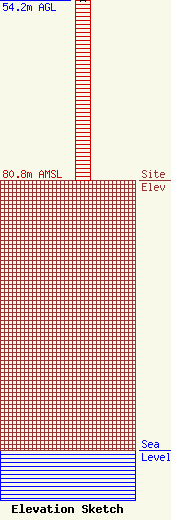
| Elevation Info |
Site Elevation: 80.8 meters (265 ft) |
| Height of Structure: 54.2 meters (178 feet) |
| Overall Height Above Ground: 54.2 meters (178 feet) |
| Overall Height Above Mean Sea Level: 135 meters (443 feet) |
| Owner Info | Pressly Enterprises, LLC
314 Union Street
Jonesboro, AR 72401
(870) 933-8800
trey@thefox1049.com |
| Contact Info | Carl E. Smith Consulting Engineers
2324 N. Cleveland-Massillon Road
807
Bath, OH 44210
Roy Stype
(330) 659-4440
|
