|
|
Antenna Structure Registration 1210889 |
 |
Registration Info | Registration Number: 1210889 |
| File Number: A1157905 |
| FAA Study: 2018-ASO-18377-OE |
| FAA Issue Date: 12/17/2018 |
| Status: Constructed |
| Date Constructed: 04/10/2019 |
| NEPA: N |
Structure Info
| Structure Type: LTOWER |
| Structure Coordinates: 30-30-34.7 N 84-20-6.6 W (NAD 83) |
| Structure Coordinates: 30-30-34.0 N 84-20-07.0 W (Converted to NAD 27) |
| Structure Address: Highway 27 At Lake Forest |
| Structure City: Tallahassee, FL |
| Structure County: Leon County |
| Painting & Lighting Info |
FAA Circular #: 70/7460-1L |
FAA Chapters: 3, 4, 5, 12 |
Remarks: Removed expiration date from determination. Scenario 1./jjs/case#635066 |
Remarks: PRIOR STUDY 1999-ASO-4872-OE |
Remarks: Removed expiration date from determination. Scenario 1./jjs/case#635066 |
Remarks: PRIOR STUDY 1999-ASO-4872-OE |
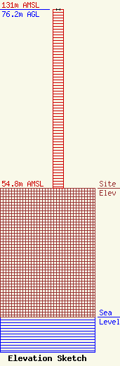
| Elevation Info |
Site Elevation: 54.8 meters (180 ft) |
| Height of Structure: 76.2 meters (250 feet) |
| Overall Height Above Ground: 76.2 meters (250 feet) |
| Overall Height Above Mean Sea Level: 131 meters (430 feet) |
| Owner Info | Faith Radio Network, Inc.
181000
Tallahassee, FL 32318
(850) 201-1070
scott@faithradio.us |
| Contact Info | EME Communications
293 JC Saunders Road
Moultrie, GA 31768
Clyde Scott
(229) 881-0199
cscott229@windstream.net |
