|
|
Antenna Structure Registration 1211383 |
 |
Registration Info | Registration Number: 1211383 |
| File Number: A1315836 |
| FAA Study: 2025-AWP-6091-OE |
| FAA Issue Date: 06/10/2025 |
| Status: Constructed |
| Date Constructed: 09/21/2006 |
| NEPA: N |
Structure Info
| Structure Type: GTOWER |
| Structure Coordinates: 35-39-7.0 N 114-18-43.8 W (NAD 83) |
| Structure Coordinates: 35-39-07.0 N 114-18-40.9 W (Converted to NAD 27) |
| Structure Address: 8125 W. 19th Street (370261) |
| Structure City: Dolan Springs, AZ |
| Structure County: Mohave County |
| Painting & Lighting Info |
FAA Circular #: 70/7460-1L |
FAA Chapters: 4, 9, 12 |
Remarks: PRIOR STUDY 2016-AWP-9238-OE |
Remarks: OM&L to remain the same as prior study = A HIGH-DUAL SYSTEM |
Remarks: PRIOR STUDY 2016-AWP-9238-OE |
Remarks: OM&L to remain the same as prior study = A HIGH-DUAL SYSTEM |
| Elevation Info |
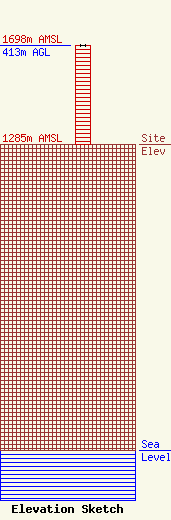
Site Elevation: 1285 meters (4216 ft) |
| Height of Structure: 412.1 meters (1352 feet) |
| Overall Height Above Ground: 413 meters (1355 feet) |
| Overall Height Above Mean Sea Level: 1698 meters (5571 feet) |
| Owner Info | American Towers LLC
10 Presidential Way
Woburn, MA 01801
(781) 926-4500
faa-fcc@americantower.com |
| Contact Info | American Towers LLC
10 Presidential Way
Woburn, MA 01801
(781) 926-4500
faa-fcc@americantower.com |
