|
|
Antenna Structure Registration 1211429 |
 |
Registration Info | Registration Number: 1211429 |
| File Number: A1162821 |
| FAA Study: 2006-agl-2492-oe |
| FAA Issue Date: 05/05/2006 |
| Status: Constructed |
| Date Constructed: 10/01/1993 |
| FAA EMI: N |
| NEPA: N |
Structure Info
|
| Structure Coordinates: 42-13-31.4 N 89-2-52.0 W (NAD 83) |
| Structure Coordinates: 42-13-31.3 N 89-02-51.6 W (Converted to NAD 27) |
| Structure Address: 2830 Sandy Hollow Road |
| Structure City: Rockford, IL |
| Structure County: Winnebago County |
| Painting & Lighting Info |
FAA Chapters: NONE |
Remarks: PRIOR STUDY 2005-AGL-3537-OE |
| Elevation Info |
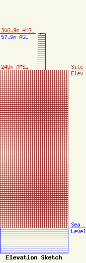
Site Elevation: 249 meters (817 ft) |
| Height of Structure: 57.9 meters (190 feet) |
| Overall Height Above Ground: 57.9 meters (190 feet) |
| Overall Height Above Mean Sea Level: 306.9 meters (1007 feet) |
| Owner Info | Long Nine, Inc.
460
Springfield, IL 62705
(217) 629-7077
mpaterson@rmgmwf.com |
| Contact Info | Long Nine, Inc.
460
Springfield, IL 62705
(217) 629-7077
mpaterson@rmgmwf.com |
