|
|
Antenna Structure Registration 1212470 |
 |
Registration Info | Registration Number: 1212470 |
| File Number: A1185802 |
| FAA Study: 99-ASW-4254-OE |
| Status: Dismantled |
| Date Constructed: 08/15/2000 |
| FAA EMI: N |
| NEPA: N |
Structure Info
|
| Structure Coordinates: 35-43-38.1 N 97-52-31.2 W (NAD 83) |
| Structure Coordinates: 35-43-37.9 N 97-52-30.0 W (Converted to NAD 27) |
| Structure Address: 6 Miles East On Waterloo Road |
| Structure City: Okarche, OK |
| Structure County: Kingfisher County |
| Painting & Lighting Info |
FAA Circular #: 70/7460-1J |
FAA Chapters: 3, 4, 5, 13 |
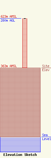
| Elevation Info |
Site Elevation: 363 meters (1191 ft) |
| Height of Structure: 259 meters (850 feet) |
| Overall Height Above Ground: 260 meters (853 feet) |
| Overall Height Above Mean Sea Level: 623 meters (2044 feet) |
| Owner Info | Perry Media Group, LLC
1528 NE 23RD ATREET
Oklahoma City, OK 73111
(405) 210-1140
Kperry@kvsp.com |
| Contact Info | Perry Media Group, LLC
1528 NE 23RD ATREET
Oklahoma City, OK 73111
(405) 210-1140
Kperry@kvsp.com |
