|
|
Antenna Structure Registration 1212752 |
 |
Registration Info | Registration Number: 1212752 |
| File Number: A1381075 |
| FAA Study: 99-asw-4554-oe |
| FAA Issue Date: 04/06/2000 |
| Status: Constructed |
| Date Constructed: 09/19/2012 |
| FAA EMI: N |
| NEPA: N |
Structure Info
| Structure Type: TOWER |
| Structure Coordinates: 32-16-31.6 N 99-35-24.6 W (NAD 83) |
| Structure Coordinates: 32-16-31.1 N 99-35-23.3 W (Converted to NAD 27) |
| Structure Address: 9.38 Nautical Miles Sse Of Abilene Regional Airport |
| Structure City: Clyde, TX |
| Structure County: Callahan County |
| Painting & Lighting Info |
FAA Circular #: 70/7460-1K |
FAA Chapters: 4, 9, 12 |
Remarks: Removed expiration and final dates from determination. Scenario 2./jjs/case#635066 |
| Elevation Info |
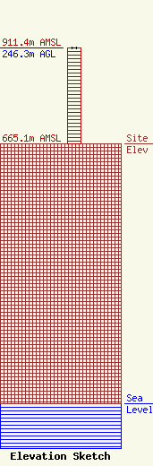
Site Elevation: 665.1 meters (2182 ft) |
| Height of Structure: 245.9 meters (807 feet) |
| Overall Height Above Ground: 246.3 meters (808 feet) |
| Overall Height Above Mean Sea Level: 911.4 meters (2990 feet) |
| Owner Info | KTVK, Inc.
8401 Greensboro Drive
McLean, VA 22102
(703) 873-6600
lawdept@tegna.com |
| Contact Info | TEGNA Inc.
8401 Greensboro Drive
McLean, VA 22102
Denise Branson
(703) 873-6606
dbranson@tegna.com |
