|
|
Antenna Structure Registration 1213154 |
 |
Registration Info | Registration Number: 1213154 |
| File Number: A0565048 |
| FAA Study: 01-ANM-2821-OE |
| FAA Issue Date: 07/24/2001 |
| Status: Constructed |
| Date Constructed: 06/29/1977 |
| FAA EMI: Y |
| NEPA: N |
Structure Info
| Structure Type: TOWER |
| Structure Coordinates: 44-29-42.0 N 109-9-12.0 W (NAD 83) |
| Structure Coordinates: 44-29-42.2 N 109-09-09.5 W (Converted to NAD 27) |
| Structure Address: Atop Cedar Mountain |
| Structure City: Cody, WY |
| Structure County: Park County |
| Painting & Lighting Info |
FAA Circular #: 70/7460-1K |
FAA Chapters: 3, 4, 5, 12 |
Remarks: Removed expiration date from determination. Scenario 1./jjs/case#635066 |
Remarks: PRIOR STUDY 99-ANM-1401-OE |
Remarks: Removed expiration date from determination. Scenario 1./jjs/case#635066 |
Remarks: PRIOR STUDY 99-ANM-1401-OE |
| Elevation Info |
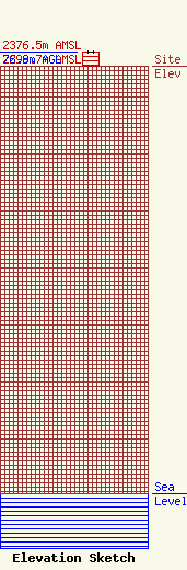
Site Elevation: 2299.7 meters (7545 ft) |
| Height of Structure: 76.2 meters (250 feet) |
| Overall Height Above Ground: 76.8 meters (252 feet) |
| Overall Height Above Mean Sea Level: 2376.5 meters (7797 feet) |
| Owner Info | Legend Communications of Wyoming, LLC
6805 Douglas Legum Drive, Suite 100
Elkridge, MD 21075
(410) 799-1740
larry@patcomm.com |
| Contact Info | Sciarrino & Associates, PLLC
5425 Tree Line Drive
1210
Centreville, VA 20120
Dawn Sciarrino
(703) 830-1679
dawn@sciarrinolaw.com |
