|
|
Antenna Structure Registration 1213524 |
 |
Registration Info | Registration Number: 1213524 |
| File Number: A0891892 |
| FAA Study: 2012-ACE-4141-OE |
| FAA Issue Date: 01/24/2013 |
| Status: Constructed |
| Date Constructed: 08/01/1992 |
| FAA EMI: N |
| NEPA: N |
Structure Info
| Structure Type: GTOWER |
| Structure Coordinates: 37-17-5.0 N 100-21-3.0 W (NAD 83) |
| Structure Coordinates: 37-17-04.9 N 100-21-01.5 W (Converted to NAD 27) |
| Structure Address: 909 West Carthage Meade Kansas |
| Structure City: Meade, KS |
| Structure County: Meade County |
| Painting & Lighting Info |
FAA Chapters: NONE |
Remarks: PRIOR STUDY 1992-ACE-381-OE |
| Elevation Info |
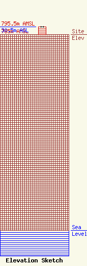
Site Elevation: 765 meters (2510 ft) |
| Height of Structure: 30.5 meters (100 feet) |
| Overall Height Above Ground: 30.5 meters (100 feet) |
| Overall Height Above Mean Sea Level: 795.5 meters (2610 feet) |
| Owner Info | Great Plains Christian Radio Inc
991
Meade, KS 67864
(316) 873-2991
kjil@kjil.com |
| Contact Info | Great Plains Christian Radio Inc
909 W. CARTHAGE
991
Meade, KS 67864
MICHAEL LUSKEY
(316) 873-2991
kjil@kjil.com |
