|
|
Antenna Structure Registration 1213857 |
 |
Registration Info | Registration Number: 1213857 |
| File Number: A1383275 |
| FAA Study: 87-ACE-0152-OE |
| FAA Issue Date: 08/21/1987 |
| Status: Constructed |
| Date Constructed: 11/10/1987 |
| FAA EMI: N |
| NEPA: N |
Structure Info
| Structure Type: TOWER |
| Structure Coordinates: 39-2-21.0 N 95-26-59.9 W (NAD 83) |
| Structure Coordinates: 39-02-21.0 N 95-26-59.0 W (Converted to NAD 27) |
| Structure Address: 2092 E 175 Rd 5 Km West Of |
| Structure City: Lecompton, KS |
| Structure County: Douglas County |
| Painting & Lighting Info |
FAA Circular #: 70/7460-1G |
FAA Chapters: 4, 6, 9 |
Remarks: HIGH INTENSITY WHITE LIGHTS |
| Elevation Info |
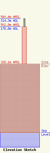
Site Elevation: 326.1 meters (1070 ft) |
| Height of Structure: 176.8 meters (580 feet) |
| Overall Height Above Ground: 214.3 meters (703 feet) |
| Overall Height Above Mean Sea Level: 540.4 meters (1773 feet) |
| Owner Info | Intentional Life Media
7355 North Oracle
Tucson, AZ 85704
(520) 219-7708
abiddell@ilmedia.org |
| Contact Info | Intentional Life Media
7355 North Oracle
Tucson, AZ 85704
Adam Biddell
(520) 219-7708
abiddell@ilmedia.org |
