|
|
Antenna Structure Registration 1214449 |
 |
Registration Info | Registration Number: 1214449 |
| File Number: A1381076 |
| FAA Study: 00-ASW-1710-OE |
| FAA Issue Date: 06/23/2000 |
| Status: Constructed |
| Date Constructed: 01/15/2000 |
| FAA EMI: N |
| NEPA: N |
Structure Info
| Structure Type: TOWER |
| Structure Coordinates: 27-42-48.6 N 97-22-47.0 W (NAD 83) |
| Structure Coordinates: 27-42-47.5 N 97-22-46.0 W (Converted to NAD 27) |
| Structure Address: 5002 South Padre Island Drive |
| Structure City: Corpus Christi, TX |
| Structure County: Nueces County |
| Painting & Lighting Info |
FAA Chapters: NONE |
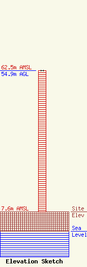
| Elevation Info |
Site Elevation: 7.6 meters (25 ft) |
| Height of Structure: 54.9 meters (180 feet) |
| Overall Height Above Ground: 54.9 meters (180 feet) |
| Overall Height Above Mean Sea Level: 62.5 meters (205 feet) |
| Owner Info | KTVK, Inc.
8401 Greensboro Drive
McLean, VA 22102
(703) 873-6600
lawdept@tegna.com |
| Contact Info | TEGNA Inc.
8401 Greensboro Drive
McLean, VA 22102
Denise Branson
(703) 873-6606
dbranson@tegna.com |
