|
|
Antenna Structure Registration 1214716 |
 |
Registration Info | Registration Number: 1214716 |
| File Number: A0204311 |
| FAA Study: 98-ASO-5952-OE |
| FAA Issue Date: 10/16/1998 |
| Status: Constructed |
| Date Constructed: 10/25/1998 |
| FAA EMI: Y |
| NEPA: N |
Structure Info
| Structure Type: MAST |
| Structure Coordinates: 30-26-4.7 N 89-1-47.1 W (NAD 83) |
| Structure Coordinates: 30-26-04.0 N 89-01-47.0 W (Converted to NAD 27) |
| Structure Address: 10250 Lorraine Road |
| Structure City: Gulfport, MS |
| Structure County: Harrison County |
| Painting & Lighting Info |
FAA Chapters: NONE |
Remarks: Removed expiration date from determination. Scenario 1./jjs/case#635066 |
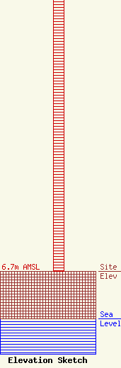
| Elevation Info |
Site Elevation: 6.7 meters (22 ft) |
| Height of Structure: 45.7 meters (150 feet) |
| Overall Height Above Ground: 45.7 meters (150 feet) |
| Overall Height Above Mean Sea Level: 52.4 meters (172 feet) |
| Owner Info | JMD, INC.
2639
Gulfport, MS 39505
(228) 896-5500
|
