|
|
Antenna Structure Registration 1215337 |
 |
Registration Info | Registration Number: 1215337 |
| File Number: A1247498 |
| FAA Study: 2022-AWP-19688-OE |
| FAA Issue Date: 11/22/2022 |
| Status: Constructed |
| Date Constructed: 06/13/2023 |
| NEPA: N |
Structure Info
| Structure Type: MTOWER |
| Structure Coordinates: 34-8-37.2 N 118-1-58.3 W (NAD 83) |
| Structure Coordinates: 34-08-37.2 N 118-01-55.1 W (Converted to NAD 27) |
| Structure Address: 35 W. St Joseph St La03xc119 |
| Structure City: Arcadia, CA |
| Structure County: Los Angeles County |
| Painting & Lighting Info |
FAA Chapters: NONE |
Remarks: PRIOR STUDY 2013-AWP-4922-OE |
| Elevation Info |
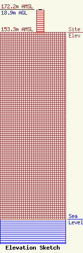
Site Elevation: 153.3 meters (503 ft) |
| Height of Structure: 18.3 meters (60 feet) |
| Overall Height Above Ground: 18.9 meters (62 feet) |
| Overall Height Above Mean Sea Level: 172.2 meters (565 feet) |
| Owner Info | STC One, LLC
12920 SE 38th Street
Bellevue, WA 98006
(425) 383-8401
FCCRegulatoryComplianceContact@T-Mobile.com |
| Info |
