|
|
Antenna Structure Registration 1215348 |
 |
Registration Info | Registration Number: 1215348 |
| File Number: A1211432 |
| FAA Study: 2015-AWP-11716-OE |
| FAA Issue Date: 01/07/2016 |
| Status: Constructed |
| Date Constructed: 08/01/1997 |
| NEPA: N |
Structure Info
| Structure Type: MTOWER |
| Structure Coordinates: 34-6-25.0 N 118-2-11.2 W (NAD 83) |
| Structure Coordinates: 34-06-25.0 N 118-02-08.0 W (Converted to NAD 27) |
| Structure Address: 141 W. Live Oak Ave. La03xc010 |
| Structure City: Arcadia, CA |
| Structure County: Los Angeles County |
| Painting & Lighting Info |
FAA Chapters: NONE |
Remarks: PRIOR STUDY 2007-AWP-5369-OE |
| Elevation Info |
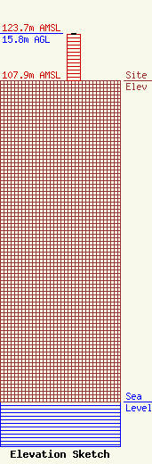
Site Elevation: 107.9 meters (354 ft) |
| Height of Structure: 15.5 meters (51 feet) |
| Overall Height Above Ground: 15.8 meters (52 feet) |
| Overall Height Above Mean Sea Level: 123.7 meters (406 feet) |
| Owner Info | STC One, LLC
12920 SE 38th Street
Bellevue, WA 98006
(425) 383-8401
FCCRegulatoryComplianceContact@T-Mobile.com |
| Info |
