|
|
Antenna Structure Registration 1215843 |
 |
Registration Info | Registration Number: 1215843 |
| File Number: A1049610 |
| FAA Study: 00-AGL-1178-OE |
| FAA Issue Date: 06/22/2000 |
| Status: Constructed |
| Date Constructed: 03/17/2001 |
| FAA EMI: N |
| NEPA: N |
Structure Info
| Structure Type: TOWER |
| Structure Coordinates: 39-56-56.0 N 88-50-12.9 W (NAD 83) |
| Structure Coordinates: 39-56-55.9 N 88-50-12.6 W (Converted to NAD 27) |
| Structure Address: 200 East Jordan Road |
| Structure City: Oreana, IL |
| Structure County: Macon County |
| Painting & Lighting Info |
FAA Circular #: 70/7460-1K |
FAA Chapters: 4, 7, 12 |
Remarks: Removed expiration and final dates from determination. Scenario 2./jjs/case#635066 |
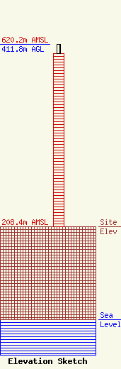
| Elevation Info |
Site Elevation: 208.4 meters (684 ft) |
| Height of Structure: 390.1 meters (1280 feet) |
| Overall Height Above Ground: 411.8 meters (1351 feet) |
| Overall Height Above Mean Sea Level: 620.2 meters (2035 feet) |
| Owner Info | GOCOM Media of Illinois, LLC
400 Main St.
Hilton Head, SC 29926
(843) 342-4405
ricgorman@gmail.com |
| Contact Info | GOCOM Media of Illinois, LLC
3003 Old Rochester Road
Springfield, IL 62703
Jack Richardson
(217) 523-8855
jrichardson@foxillinois.com |
