|
|
Antenna Structure Registration 1215918 |
 |
Registration Info | Registration Number: 1215918 |
| File Number: A1286585 |
| FAA Study: 2024-ASW-6548-OE |
| FAA Issue Date: 06/12/2024 |
| Status: Constructed |
| Date Constructed: 09/29/2000 |
| NEPA: N |
Structure Info
| Structure Type: GTOWER |
| Structure Coordinates: 30-46-36.6 N 91-1-28.8 W (NAD 83) |
| Structure Coordinates: 30-46-35.9 N 91-01-28.4 W (Converted to NAD 27) |
| Structure Address: 4087 Highway 67 South (la03997-s ) |
| Structure City: Clinton, LA |
| Structure County: East Feliciana Parish |
| Painting & Lighting Info |
FAA Circular #: 70/7460-1J |
FAA Chapters: 4, 8, 13 |
Remarks: OM&L to remain the same as prior study = A MED-DUAL SYSTEM |
Remarks: PRIOR STUDY 2000-ASW-3354-OE |
Remarks: OM&L to remain the same as prior study = A MED-DUAL SYSTEM |
Remarks: PRIOR STUDY 2000-ASW-3354-OE |
| Elevation Info |
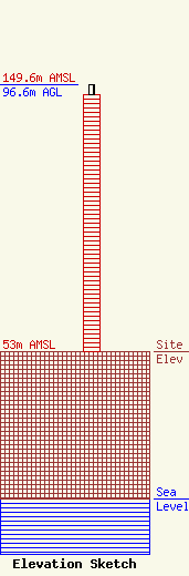
Site Elevation: 53 meters (174 ft) |
| Height of Structure: 93 meters (305 feet) |
| Overall Height Above Ground: 96.6 meters (317 feet) |
| Overall Height Above Mean Sea Level: 149.6 meters (491 feet) |
| Owner Info | SBA Towers, LLC
8051 Congress Avenue
Boca Raton, FL 33487
(561) 995-7670
ERoach@sbasite.com |
| Contact Info | SBA Towers, LLC
8051 Congress Avenue
Boca Raton, FL 33487
(561) 995-7670
ERoach@sbasite.com |
